Tennessee
(Sightseeing)
January 7, 2018 - January 15, 2018
From Clinton, TN we drove north to the Cumberland Gap, an area made famous by Daniel Boone. It is at the juncture of the Kentucky, Virginia and Tennessee borders. We had planned on staying at the National Park Campground but we found it was closed for the season. Sometimes the "app" we use to find campgrounds gets it wrong and that can be frustrating. We found out they now close for the winter season because several years ago they had people camping in the park when it snowed and they couldn't get people out until the snow melted. We found another campground in the nearby town of Harrowgate so we set out to find it. Following the directions on our phone we turned down a small road, then drove for 5 miles while we prayed that no RV would come towards us from the other direction. It was such a narrow road that I was sure we had gone the wrong direction and I wondered how we would ever get turned around. Several oncoming cars slowly passed us and we finally made it to the end of the road. There we found a very nice campground. Most of the rigs seemed to be there full time but used only during the summer months. Once we got set up all I had to worry about was getting the motorhome out when we left.
 |
| The campground was right along side the Powell River. |
 |
Still enduring mighty cold weather.
This falls was just across the road by the campground. |
The next day we visited the Abraham Lincoln Library and Museum on the campus of Lincoln Memorial University in Harrowgate. It turned out to be a strange experience. When we arrived there was no one at the reception desk so we wandered around for a bit thinking they'd be right back. Still no one arrived so we called out and explored the building a bit to see if anyone was there. Couldn't find anyone! We decided to just look around and felt surely someone would eventually show up but most of the lights were turned off which made looking at the exhibits a bit difficult. I tried calling the number and the phone rang sure enough but of course no one answered. We finally decided to go have some lunch. After lunch we came back and still no one was there. I called the campus police and told them what the situation was. They told us the campus was closed due to the weather so the museum should not be open. They said they'd send someone over. When the policeman got there we explained everything and went on our way. The next day we went back and, since there was no police tape, we went in. They told us we created a bit of chaos but we could go through the exhibits for free. We still don't know exactly what happened but it's one visit I won't soon forget.
 |
| Should have taken that small bronze of Lincoln while I could!!! |
 |
| They have many pictures of Lincoln - most of which were unfamiliar to me. |
 |
| This was my favorite picture of Lincoln. |
 |
| Diorama of Lincoln with his cabinet members. |
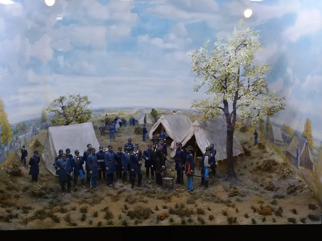 |
| Diorama of Lincoln with the Union Troops. |
 |
| Cannon ball embedded in a tree. |
In the early 1700's the Appalachian mountains prevented European settlers from moving west from Virginia and North Carolina. In 1750 Dr. Thomas Walker was exploring when he "found" a passage through the mountains which he later named "The Cumberland Gap." Of course bison and other animals as well as Native Americans had been using this gap (or pass) for thousands of years but Dr. Walker is credited with "discovering" it. In 1775 Daniel Boone, who had previously been through the gap on several hunting expeditions, was hired to lead a group of 30 men through the gap and create a "road" which would allow settlers to move west into what is now Kentucky and Tennessee.
 |
It was called the Wilderness Road but road is a bit of a misnomer. They created a trail used by more than 200,000 people as they walked or rode west in search of land.
It wasn't until after about 1810 that an actual road suitable for wagons was created. |
Daniel Boone will be forever linked to opening up the "west" but he paid a heavy price. His two oldest sons were killed on Cumberland gap in separate incidents with Native Americans.
 |
| View of the gap from Pinnacle Overlook. It runs just below the hill I'm standing on and the closest hill beyond. |
 |
Panoramic view from Pinnacle Overlook. We're standing in Virginia.
The town in the distance is Middlesboro, Kentucky. The state of Tennessee is to the left.
The small peak in the foreground is Tri-State Peak where the three states meet as shown below. |
Because of it's passage through the Appalachian mountains, the gap was a strategic location during the Civil War. With only rare exceptions, it was held by the North during the war. They built earthworks and placed cannons on the sides of the hills overlooking the gap. As proof here's a picture of a canon behind some of those earthworks.
 |
Here's the mystery to me. To place that canon where it is they had to get it up the hill and over these rocks.
What an effort that must have been! |
Just have to share one last picture from the town of Cumberland Gap.
 |
We think this water wheel must have been moving until it finally froze up in the cold.
The strange shapes of the ice sure caught our eyes. |
Our next stop was Pigeon Forge/Gatlinburg, Tennessee. Both towns are highly geared to attract tourists. The sheer number of attractions can be a bit overwhelming, not to mention EXPENSIVE!
Of course January is not the prime time to visit either of these places so we were spared the need to navigate huge crowds but that also means many of the major attractions were closed for the winter. After looking around a bit we choose to look for some specific types of artists on what they call the "Arts and Crafts Loop" in Gatlinburg. We ended up visiting a woodworker's studio and a glass artist's studio, both of which were very interesting. Also made it briefly into a leatherworkers studio but he had to leave in a hurry in order to deal with a real estate transaction. No pictures to share of those exploits.
We took a drive along the edge of the Smokey Mountains one day and saw some beautiful scenery. We also discovered why they are called the Smokies.
 |
The Smoky Mountains after a snow squall the night before.
The name Smoky comes from the blue mist that hovers over the peaks and valleys.
This area receives upwards of 80 inches of rain a year, qualifying it as a rain forest.
The blue mist is a result of gases given off by all the trees and other vegetation in the forest.
The vapors come together to create the mist or fog which hangs over the area, giving it a smoky look. |
 |
One of the most interesting things we noticed almost immediately were the many rhododendrons along side the road.
In some cases entire hills were covered with them. Driving this road in the spring must be quite a sight. |
 |
| This is the Little River as it flows under one of the many bridges. |
 |
| The whole area is very rocky creating some beautiful scenery. |
One night we decided to go to the Comedy Barn and pack in some laughter and enjoy some music.
 |
| The players |
 |
| The musicians |
 |
| Fun dog show. Every single dog came from a rescue center. |
It was quite a kick, frequently at the expense of audience members chosen at random by the performers.
 |
These poor fellows had to move a certain way depending on whether they were tapped on the head or shoulders.
It still makes me laugh to think about it. |
 |
| Four guys sitting on buckets then laying on the lap of the fellow behind them. |
 |
Take the buckets away and watch them fall down. Nope! Somehow they stayed in place.
The performer is asking them questions all the while. |
 |
It's a family show and there were lots of kids in the audience.
They all got to go on stage before a few were singled out for some special fun. |
We didn't get pictures of every act but we came away filled with endorphins from all the laughter.
Our last stop was to a Salt and Pepper museum. I guess it just proves you can find a museum to just about everything. The collection is the work of just one woman who collected over 20,000 sets of salt and pepper shakers. In some cases it was a walk down memory lane.
In general the sets are grouped by subject such as in the pictures below - Christmas and Vegetables.
I wish I had counted how many separate groupings were in the museum but I can tell you there were many! Just when you'd think you must have seen them all you'd turn a corner and there was still more to see.
It seems just about anything is fodder for a salt and pepper shaker set. In just the single picture above you have, mushrooms, snails, tomatoes, yellow squash, asparagus, radishes, hot peppers, celery, carrots, eggplants, and many others. I guess various types of food are an obvious choice for a set but what about....
 |
| TVs |
 |
| Refrigerators, sewing machines, mixers |
 |
| Native Americans, tipis, frogs and lilly pads, canoes, totem poles |
 |
| Irons, chairs, barrels, stoves |
 |
| Outhouses and chamber pots |
 |
| barbecues, catsup and fries, Italian chefs |
 |
| whatever these are (other than disturbing)? |
 |
| crabs and lobsters and their traps |
 |
| the sun and the moon and a moon an an angel |
 |
| Space exploration, army tanks, mail delivery trucks |
 |
| RVs |
 |
| cacti and saddles |
 |
| ice cream cones, golf balls, wine and cheese |
 |
| coffee pot and toaster, ice cream soda glasses |
 |
| coca cola products |
 |
| nuns, friars, kings and queens, chess pieces, royal coaches |
 |
| piggies |
 |
| dalmatians and fire hydrants or fire hats |
 |
| fish in a creel |
 |
| toilets |
 |
| the Beatles |
The list goes on and on! We got quite a kick out of all the various ideas used to make something we all use frequently but don't think much about. It was well worth the $3.00 price of entry.
On the day we planned to leave we woke up to this....
 |
Not a lot of snow but we decided to hunker down for another day and hope it was gone by the next morning.
For the most part - it was! |


