North Carolina - part two
(Sightseeing)
May 3, 2018 - May 12, 2018
A visit to the North Carolina coast wouldn't be complete without a trip to the Outer Banks. Their history is one of pirates, ship wrecks, beaches, hurricanes and inhabitants who, of necessity, had to be very self sufficient. They consist of Cape Lookout at the southern end and Cape Hatteras at the northern end. Cape Lookout is accessible only by ferry and if you're staying overnight your choices are rustic cabins or a tent! Cape Hatteras consists of 3 islands, Ocracoke, Hatteras and Bodie. Ocracoke, the southernmost island is accessible from the mainland only by ferry (2 1/2 hour ride) or private boat. A free ferry connects Ocracoke island to Hatteras island (20-30 minute ride) and a bridge connects Hatteras island to Bodie island. A bridge also connects Hatteras island to the mainland at the town of Nags Head. Looking at a map before we got there I actually found myself wondering if there were such conveniences as gas stations, grocery stores, etc. I needed have worried - it's all pretty civilized now-a-days.
The night before we took the ferry to the town of Ocracoke on Ocracoke island, we camped as close to the ferry terminal as we could. Along the coast of North Carolina - you can drive in just about any direction and eventually run into water.
 |
| Looking out over the Pungo River. |
 |
| Nice sunset from the campground. Pungo River is in the background. |
 |
| Ferry landing at Swanquarter, NC |
 |
| There's our ferry. The whole boarding process seemed so familiar - almost like being at home. |
Ocracoke Island
Pirates were a fact of life back in the early 1700's. One of the most famous was Blackbeard (aka Edward Teach). He began his life as a pirate in about 1716 working with another pirate named Hornigold. He was known for his boldness, courage, marksmanship and thurst for blood. Acting together they plundered ships from the Caribbean to New York. In 1717 he captured a French ship named Concord which he renamed "Queen Ann's Revenge." He and Hornigold parted ways and Blackbeard used Queen Ann's Revenge as his flagship. For some reason he beached the ship near Beaufort, NC where it eventually sank. He picked up another ship named "Adventure" and continued to harass and plunder ships. Late in 1718, while anchored near Ocracoke, a group of soldiers and sailors organized by the Governor of Virginia, found his ship and tried to capture Blackbeard. He was killed in the battle, his head severed from his body and tied to the bowsprit of the Adventure which was taken back to Virginia. In all his pirate career lasted only two years but his legend lives on and in Ocracoke there is a small museum dedicated to telling his story.
 |
| Artist's rendition of Blackbeard. |
 |
What interested me about this was the number of guns on some of these ships and the number of crew on board.
40 guns (I assume that means cannons) and 300 crew members! |
 |
| Adventure - Blackbeard's last ship |
 |
| Looking north along the Atlantic side of Ocracoke Island |
 |
| Barney and I look for shells and pick up plastic junk. |
 |
24 x 7 x 365 - the breakers roll in.
If we could harness that energy! |
 |
Panorama of the Banker Pony Pens on Ocracoke Island.
The pens and the ponies are looked after by the National Park Service Employees.
The facility where they are kept is very good quality. |
 |
Banker ponies are feral and are believed to be the descendants of horses brought from Spain in the 1600's.
I couldn't detect the difference but they are slightly smaller than regular horses and, oddly,
they have one less vertebra and one less set of ribs than regular horses. |
 |
One night while we were on Ocracoke it started raining and it just kept on and on.
This was how the camp area across the road from our site (off to the left of the picture) looked by mid-morning. |
 |
Directly across the street from our site.
We were fortunate to be in an area that was slightly higher so we did not get flooded out. |
 |
| We really felt sorry for these poor folks. |
Hatteras Island
We were scheduled to camp at a national park campground named Cape Point - right where the Cape Hatteras Light house is located. We arrived to find this....
 |
| Laura took the car and drove around to see if there were any usable sites but virtually everything was fully or partially flooded. |
We backtracked to another National Park campground and asked if we could switch our reservations since the other park was flooded. They were OK with that so we got ourselves set up there.
Our first outing was to the Graveyard of the Atlantic Museum. Cape Hatteras has a well deserved reputation for ship wrecks. One reason for the many wreaks is an area called "the diamond shoals," a shifting bunch of sandbars right off the tip of Cape Hatteras. They are easy to see in this NASA photo.

In addition the Gulf Stream and the North Atlantic Drift meet head on right about there causing big problems for sailors trying to get around Cape Hatteras and those dangerous shoals. The museum features many artifacts removed from sunken ships in the area. Unfortunately no pictures were allowed in that portion of the museum! To me the most interesting artifact was an enigma machine from a German submarine. It looked quite similar to a typewriter but a good deal more complicated. They also had an exhibit on the beginnings and growth of sport fishing in the area, showing how the gear has changed through the years and the type of fish that are caught in the area (e.g. marlins, dolphin fish, etc.) Another exhibit on what they believe is the wreak of Blackbeard's ship "Queen Ann's Revenge" was also interesting. They continue to bring up more and more items that seem to fit the profile of the lost ship.

 |
| Although much of the glass is missing this partial restoration of the light is quite amazing. |
 |
| Here you can see the steps leading directly up into the inside of the lens area. |
 |
| Sand is always encroaching on the highway. |
 |
Group setting up for kite surfing along the Pamlico sound side of Hatteras Island.
The winds in this area are generally very good for the sport. |
 |
There were so many kite surfers I don't know how they didn't run into one another.
Looks like a real adrenaline rush though. |
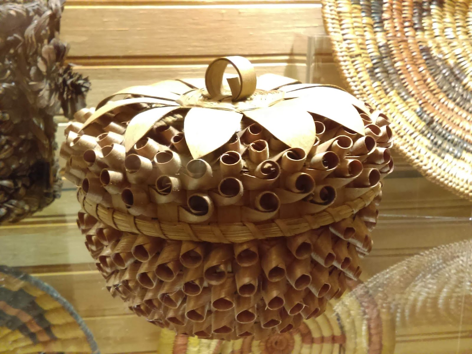
Sometime you find the most surprising museums in the most unlikely places. Such is the case with the Frisco Native American Museum. From the outside it doesn't look like much but we were amazed at the Native American items they had on display from all over the country.
 |
Since they are generally not readable I'm going to write out the "Did You Know?" portion of these signs.
Did You Know?
Music is life affirming and the songs of the earth are healing to the soul. Reduce noise pollution so that our human song can harmonize with the natural world rather than drown it out. |

 |
Did you know?
Tobacco, like most medicinal plants, was harvested very carefully. Only what was needed was taken and dried while other plants were left to seed and produce the next generation. Careful collection and monitoring ensured the survival of the plant species. |
 |
Did you know?
While Native American baskets are works of art, they are utilitarian items essential to daily life. They are made from renewable resources, are only discarded when damaged bbeyond repair and quickly biodegrade when returned to the earth. |
 |
Did you know?
Stone points and blades would often be recycled after the edge was dulled. A skilled maker would re-shape the item creating a newer, smaller piece to be used again. |
 |
Did you know?
The Hopi lifeway teaches us that the gifts of the Kachinas are rewards for the responsibility of living in harmony, caring for one another and the world around us. |
 |
Did you know?
Many tribes believed that you should not dig in the earth just to find stones. It was considered hurting the earth and stealing what didn't belong to you. However, if you stumbled across a stone or vein of stone by luck, this was looked upon as a ... |
 |
Did you know?
From their cradle that provided a secure and comforting embrace, infants learned patience and mindfulness by first watching the world before acting upon it. |
Bodie (pronounced Body) Island
Hatteras Island is connected to Bodie Island via a bridge. The old bridge seems perfectly OK so I'm not sure why a new bridge is currently under construction. Perhaps it has something to do with getting off the island when a hurricane is threatening.
Wright Brothers National Memorial at Kill Devil Hill, NC
 |
We found this information on the brother's personalities very interesting.
Between the two they seemed to have all the necessary ingredients for success. |
 |
| This granite monument was erected in 1928 to mark the 25th anniversary of the Wright's first flight. |
 |
| At the same time in 1928 the cornerstone for a monument to the Wright Brother's themselves was laid on the top of Big Kill Devil Hill. |
 |
Monument to the Wright Brothers on the top of Kill Devil Hill.
Grass was planted on the sand dune at that time in order to stabilize it. |
 |
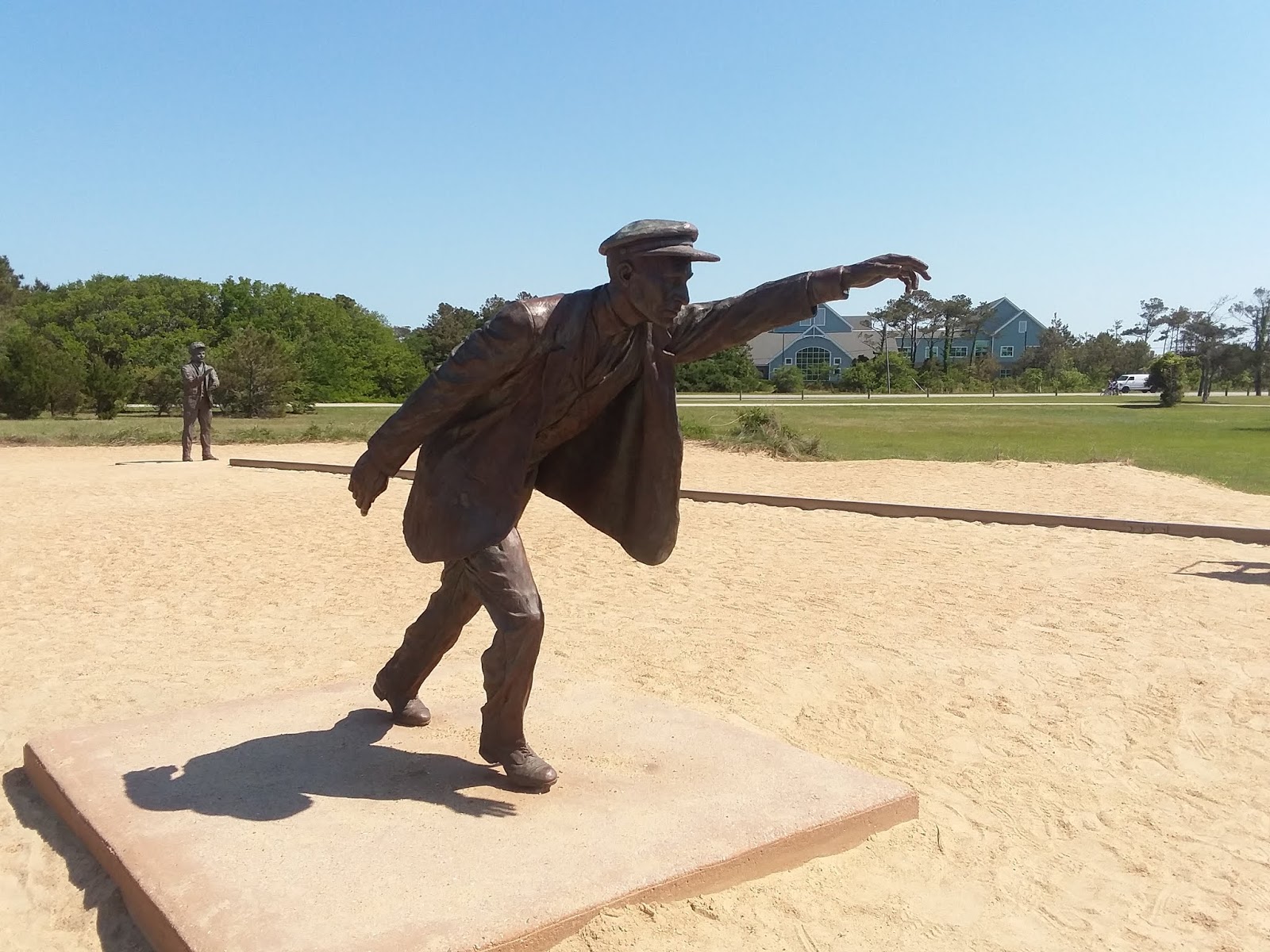
| Sculpture of the first plane taking flight. |
 |
| The first flight with Orville at the controls. |
 |
| Helpers from the local community (above and below). One was asked to take a picture of the event in spite of never operating a camera before. Three of the four helpers were members of the local life saving service. |
 |
| Wilbur runs along side of the plane steadying the wing until the plane out paced him. |
 |
| Granite markers showing the distance of the first four flights made by the Wright Brothers. |
Chicamacomico (Chik-a-ma-COM-i-co) Life Saving Station
Before the coast guard there were life saving stations all around the coastal areas of the U.S. under the auspices of the U.S. Life-Saving Service. The Chicamocomico Life Saving Station is located in the town of Rodanthe, NC. It is now a historic site and houses a museum dedicated to remembering the heroic men who served in the Life Saving Service.
 |
The equipment and boat was housed in the lower portion of the station.
The men assigned to the station slept on the second floor. |
 |
Some of the equipment used by the life saving service.
Above: life car
Below: rescue beach cart and components
Further below: breaches buoy |
 |
| Surf boat (weight 8000 lbs when fully loaded!) |
 |
Launching the surf boat.
It can sometimes take many tries to breach the breakers along the coast. |
 |
| This station was built in 1911 and served the life saving service until 1915 when the life saving service merged with the U.S. Revenue Cutter Service to form the U.S. Coast Guard. It then served the U.S. Coast Guard until it was decommissioned in 1954. It is currently undergoing some rehabilitation from storm damage. |
 |
| Picture of the life car in use during a rescue. |
 |
| Picture of the breaches buoy in use during a rescue. |
Corolla - the end of the road
We drove as far north as the road took us to the town of Corolla. It was a typical drive through areas devoid of much vegetation but full of large rental homes as well as areas with beautiful landscaping and trees. From Corolla you can take jeep rides to see the wild horses that still roam the area. Descendants of the ancestors of the same horses we saw on Ocracoke island.
 |
| Beach access near the end of the road in Corolla, NC. |
 |
| Just a few of the enormous rental homes along the coast at Corolla (and virtually every other stretch of beach). |
 |
| The Atlantic Ocean |
 |
| Wildlife education center in Corolla, NC. It was located on the west side of the island, facing Currituck Sound. |
 |
| Loved this bridge and the live oak really sets it off! |
 |
| Small marina at the education center. |
 |
| Currituck Beach light house. |